Where
Carlingford Tourist Office Old Railway Station Carlingford LouthImage Gallery

Blue arrows — Slieve Foye Loop
Green arrows - shorter Commons Loop
Red for Shorter Barnavave Loop
Yellow - long distance Táin Way
Slieve Foye Loop
This National loop walk brings you up to the mountains slopes above Carlingford. The walk is mostly on good paths marked with blue arrows.
- A-B. From the car park turn left and follow the blue (and green and red) arrows along the road to a T-junction where you turn left. The green arrows are for the shorter Commons Loop, the red for the longer Barnavave Loop. Entering the village ‘square’ turn right and ascend to the main junction where you proceed staright on to the right of Savages Victuallers. Continue to follow the green, blue and red arrows (and the yellow arrows which are for the long-distance Táin Way) as the loop takes you to the top of River Road. The green loop goes straight ahead here - but you turn right onto a sandy roadway.
- B-C. Follow the blue, red and yellow arrows along the roadway past gates and into forestry. The loop travels through the forestry for more than 1km before reaching a forestry track (on the left) where the two loops turn left and leave the Táin Way. Now you ascend gently to reach the edge of forestry and a 20m climb takes you to a stile over a wire fence. Cross the stile, turn left, and follow the wire fence for 1km to reach the end of the forestry. Veer right here.
- C-D. Continue to follow the blue and red arrows for 300m to reach a bend in a grassy roadway where you rejoin the Táin Way. The red loop turns right here - but you veer left and downhill. Follow the grassy roadway for 500m to reach a wooden gate - pass through it and follow the arrows to the left. The loop now sweeps downhill and right and, after 500m, joins a surfaced roadway. Here you rejoin the Barnavave Loop and turn left and downhill.
- D-A. The loop takes you down to the parish church on the outskirts of the village and then turns left and back to the village square. It’s only 100m from there to the trailhead.
Dogs are not permitted on farmland.
Direction:
The M1 is the motorway connecting the cities of Dublin and Belfast. Leave the M1 at Junction 18 – and join the R173 in the direction of Ballymascanlan and Carlingford. After 17km (approx) take the turn for Carlingford (R176 - signposted Carlingford) – a further 3km takes you to the village. The Tourist Office is in the main car park on your left.
Descriptions
- Ascent: 270m / 280m
- Distance: 8km / 2hr30min – 3hrs
- Grade: Hard - Above Average levels of fitness
- Minimum Gear: Hiking boots, raingear, snack, fluid and mobile phone.
- Terrain: Minor roads, laneways, hillside tracks.
- Trailhead: Tourist Office Carpark, Carlingford, Co Louth
- Grid Ref: OSI Sheet 36
Download the Map:
Download Slieve Foye Loop Map here
Barnavave Loop
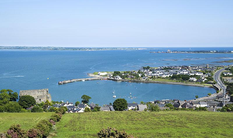
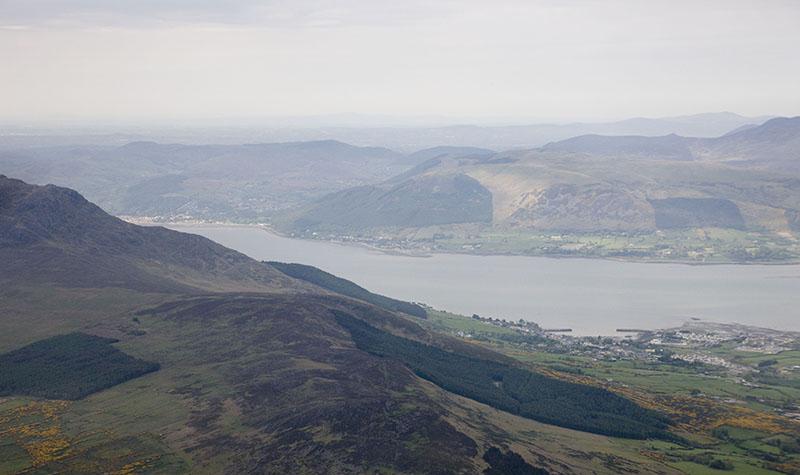
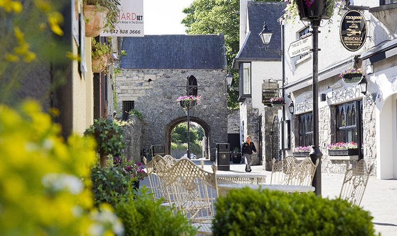
Carlingford and the Cooley Peninsula is a haven for the hiker, the hillwalker, and the view finder! The village of Carlingford nestles on the southern shore of Carlingford Lough – Slieve Foye mountain (said to be the resting place of the great giant Fionn McCool) acts as a massive and spectacular backdrop. On the far side of Carlingford Lough are the Mountains of Mourne – made famous in song. All combined, makes a place of natural beauty. The village with its medieval streets hosts a range of pubs, restaurants, craft/antique shops and much more. This area is steeped in the myth and legend of the Cattle-Raid of Cooley where Cuchulain defended Ulster single-handedly against the armies of Queen Medbh of Connaught.
Dogs are not permitted on farmland.
Direction :
The M1 is the motorway connecting the cities of Dublin and Belfast. Leave the M1 at Junction 18 – and join the R173 in the direction of Ballymascanlan and Carlingford. After 17km (approx) take the turn for Carlingford (R176 - signposted Carlingford) – a further 3km takes you to the village. The Tourist Office is in the main car park on your left.
Additional Features
- Ascent: 270m / 350m
- Distance: 14km / 3hr30min – 4hrs
- Grade: Moderate / Hard - Above average levels of fitness
- Minimum Gear: Hiking boots, raingear, snack, fluid and mobile phone
- Terrain: Minor roads, laneways, hillside tracks
- Trailhead: Tourist Office Carpark, Carlingford, Co Louth
- Grid Ref: OSI Sheet 36
Download the Map:
Barnavave Loop map - download now
Commons Loop
- A-B. From the car park, turn left and follow the green (and blue and red) arrows along the road to a T-junction where you turn left. The blue and red arrows are for the longer Slieve Foye Loop and Barnavave Loop. Entering the village ‘square’ turn right and ascend to the main junction where you proceed staright on to the right of Savages Victuallers. Continue to follow the green, blue and red arrows (and the yellow arrows which are for the long-distance Táin Way) as the loop takes you to the top of River Road. The blue and red loops turn right here - but you proceed straight ahead and join a stoney laneway.
- B-C. Follow the laneway as it zig-zags uphill for 500m to join a wide green roadway. Here you rejoin the Táin Way (yellow arrows) and the Slieve Foye Loop (blue arrows) and turn left. Follow the grassy roadway downhill for 300m to reach a wooden gate - pass through it and follow the arrows to the left. The loop now sweeps downhill and right and, after 500m, joins a surfaced roadway. Here you rejoin the Barnavave Loop and turn left and downhill.
- C-A. Continue to follow the green, red, blue and yellow arrows as the loop takes you down to the Parish Church on the outskirts of the village, and then turns left and back to the village square. It’s only 100m from there to the trailhead.
Dogs are not permitted on farmland.
Direction :
The M1 is the motorway connecting the cities of Dublin and Belfast. Leave the M1 at Junction 18 – and join the R173 in the direction of Ballymascanlan and Carlingford. After 17km (approx) take the turn for Carlingford (R176 - signposted Carlingford) – a further 3km takes you to the village. The Tourist Office is in the main car park on your left.
Additional Information
- Trailhead: Tourist Office Carpark, Carlingford, Co Louth
- Distance: 4km / 1hr – 1hr30mins
- Ascent: 250m / 200m
- Terrain: Minor roads, laneways, hillside tracks.
- Grade: Moderate - Average levels of fitness
- Minimum Gear: Trekking shoes, raingear, fluid and mobile phone.
- Grid Ref: OSI Sheet 36
Download the Map:
Molly National Loop Walk, Grange
- A-B. From the trailhead at John Long’s Pub follow the green (and purple) arrows along the surfaced road. The purple arrows are for the longer Rooskey Loop. After 500m you reach a crossroads at a place called The Acre - go straight across here and join a surfaced laneway. After 300m watch for a waymarker that directs you to your right and onto a farm laneway (Billy’s Lane). Follow the green and purple arrows as the surface changes to grass and, after 1km, join a surfaced road where you turn left. Almost immediately the loop turns left again and ascends to reach a 3-way junction where the Rooskey Loop (purple arrow) turns left - but you turn right.
- B-C. Note that you will now overlap on the Barnavave Loop from Carlingford (red arrows) for a short distance. Follow the green and red arrows downhill to reach a surfaced road where you turn left. After 150m you reach an old limekiln on your left – note that you rejoin the purple Rooskey Loop briefly here. Watch for a waymarker which directs you right onto a downhill laneway – and you leave both the Rooskey Loop and Barnavave Loop as you do. After 150m you reach a Y-junction where you have two options – the official loop turns right; straight ahead adds a short extra distance to your walk. At the end of the laneway you join a surfaced roadway where you turn right, ascend for 100m to reach the brow of the hill, and turn left onto a grassy laneway - known locally as The Molly! The laneway takes you downhill to reach another laneway (Forty’s Lane) where you rejoin the purple loop and turn right.
- C-A. After 400m the laneway crosses the R173 and joins a surfaced laneway (Skeekan’s Lane) - enjoy the last 1km back to the trailhead.
Dogs are not permitted on farmland.
Direction:
The M1 is the motorway connecting the cities of Dublin and Belfast. Leave the M1 at Junction 18 – and join the R173 in the direction of Ballymascanlan and Carlingford. Continue to follow the road for 15km passing Lordship and The Bush. Approximately 1km past The Bush turn left (L3061 - signposted Grange). Follow the road to reach St James Parish Church on your right, where car parking is available. The trailhead is located at John Long's pub directly opposite.
Download map and directions
- Ascent: 120m/150m
- Distance: 4km / 1hr – 1.5hrs
- Grade: Easy - Average level of fitness
- Minimum Gear: Trekking Shoes, raingear, snack, fluid and mobile phone.
- Terrain: Minor roads, laneways, tracks.
- Trailhead: Grange Village, Co Louth
Rooskey National Loop Walk, Grange
- A-B. From the trailhead at John Long’s Pub follow the purple (and green) arrows along the surfaced road. The green arrows are for the shorter Molly Loop. After 500m you reach a crossroads at a place called The Acre - go straight across here and join a surfaced laneway. After 300m watch for a waymarker that directs you to your right and onto a farm laneway (Billy’s Lane). Follow the purple and green arrows as the surface changes to grass and, after 1km, join a surfaced road where you turn left. Almost immediately the loop turns left again and ascends to reach a 3-way junction where the Molly Loop (green arrow) turns right - but you turn left.
- B-C. Note that you are now overlapping on the Barnavave Loop from Carlingford (red arrows) for a short distance - but going in the opposite direction. Follow the purple arrows uphill to join a forestry roadway which you follow for 400m to a left bend. Watch for a stile on your right here - cross it, climb the short ascent to reach stone walls of a deserted village and turn right (leaving the Barnavave Loop as you do). Follow the purple arrows downhill to reach a surfaced road at an old limekiln - and turn left. Note that you have rejoined the Molly Loop very briefly at this point – it turns right onto a downhill laneway – but you continue straight along the surfaced road. Follow this road for 150m before turning right onto a narrow downhill laneway located between two house entries. At the end of this 450m laneway (part grass and part surfaced) you meet the Rooskey road and turn left. Follow this road for 400m to Rooskey and then turn right onto a narrow laneway (Forty’s Lane). (At this point you are close to the site of the Rooskey Priory - after which this loop is named.) Follow the laneway for over 1km to a point where the shorter Molly Loop rejoins you from your right. Continue straight on here.
- C-A. Now follow the green and purple arrows for 400m to a junction with the R173. Go straight across and join a surfaced laneway (Skeekan’s Lane) - enjoy the last 1km back to the trailhead.
Items of Interest:
St James church, Grange. Grinding stone at end of Billy’s lane was used to crush gorse plants for horse fodder. ‘Abandoned Village’ and Limekiln (disused). Ruins of Rooskey Priory.
This loop can be accessed from Carlingford by starting on Forty’s Lane at Rooskey.
Walkers on the Barnavave loop can use ‘The Molly’ laneway and ‘Forty’s Lane’ on the return to Carlingford as an alternative to the road route.
Direction:
The M1 is the motorway connecting the cities of Dublin and Belfast. Leave the M1 at Junction 18 – and join the R173 in the direction of Ballymascanlan and Carlingford. Continue to follow the road for 15km passing Lordship and The Bush. Approximately 1km past The Bush turn left (L3061 - signposted Grange). Follow the road to reach St James Parish Church on your right, where car parking is available. The trailhead is located at John Long's pub directly opposite.
Download map and directions
- Ascent: 150m/220m
- Distance: 7km / 2hr – 2.5hrs
- Grade: Moderate - Above Average level of fitness
- Minimum Gear: Hiking boots, raingear, snack, fluid and mobile phone.
- Terrain: Minor roads, laneways, tracks.
- Trailhead: Grange Village, Co Louth
Annaloughan National Loop Walk
This National loop walk overlooks Dundalk Bay. It is mostly on track but the mountain section requires good boots. Heathery mountain slopes with a return through the pines and spruces of Rockmarshall forest.
- A-B Start from the small layby and picnic area beside the main road at Jenkinstown (Alternatively, you can park in the grounds of Fitzpatricks Bar and Restaurant) The route is marked with purple arrows and signs. From the trail head follow the arrow to the right, where a narrow road leads uphill past some houses. Follow this road for about 300m to reach a narrow laneway on your left. Turn left and follow the laneway to exit at a farm shed where you turn right (at the OPW, Rochmarshall Court Tomb). Shortly afterwards, you turn right at a T-junction and follow the roadway uphill to reach a barrier entrance to forestry. Just past the barrier turn right onto a forestry roadway.
- B-C. After just 50m continue straight on at a junction and follow the forestry roadway as it ascends to a 3-way junction from where the loop ‘proper’ begins. Information plates on the waymarker offers you the choice of doing the loop clockwise or counter-clockwise. We suggest it is best done clockwise - so continue straight on. The loop continues to ascend for the next 2km - before joining a surfaced road. Turn right.
- C-A. Follow the road for only 50m and cross a stile on your right which takes you onto a path by the edge of forestry (on your right). Keeping the forestry fence on your right, stay on this path for 1.5km as the loop crosses the shoulder of Annaloughan Mountain. Near the end of this section a slight deviation (left) from the fence takes you to a stile where you enter the forestry. Follow the stony path downhill to reach a 3-way junction where you turn left and downhill - after 300m swing right at a sharp bend and soon rejoin the outward section of the loop at the junction mentioned at B above. This time turn left and follow the purple arrows as they take you back to the trailhead.
Whist on your walk, as well as enjoying the magnificent scenery, keep an eye out for the memorial plaque erected to the crew of an RAF B-24 Liberator Mk. 2 aircraft which crashed in poor weather conditions on 14th March 1942 with a crew of six and thirteen passengers on board (of which only five survived).
Direction:
The M1 is the motorway connecting the cities of Dublin and Belfast. Leave the M1 at Junction 18 – and join the R173 in the direction of Ballymascanlan and Carlingford for 6km. The trailhead is just past Fitzpatricks Bar and Restaurant on the left hand side.
Download the map
Descriptions
- Ascent: 260m
- Distance: 8km / 2hr30min – 3hrs
- Grade: Moderate - Above Average levels of fitness
- Minimum Gear: Hiking boots, raingear, snack, fluid and mobile phone.
- Terrain: Minor roads, laneways, hillside tracks.
- Trailhead: Junction of R173 to Dundalk and R174 to Ravensdale on Dundalk to Carlingford Road, Co Louth